Satellite captures epic scale of Greenland inferno in intricate detail (PHOTO)
Published 9 Aug, 2017 23:02 | Updated 10 Aug, 2017 12:23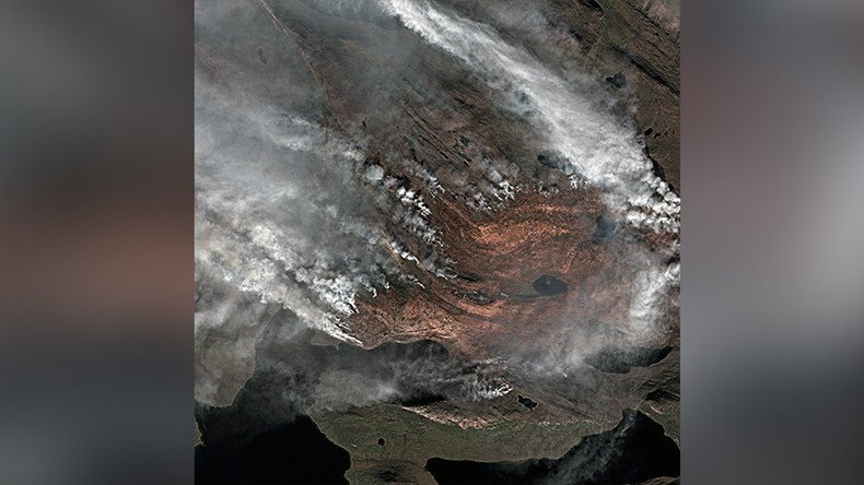
Mesmerizing satellite images of a massive wildfire in Greenland have been captured from space.
While the wildfire could possibly be the biggest in the icy country’s history, their satellite records go back only as far as the year 2000, and it’s “certainly the biggest one” in that respect, said remote-sensing scientist Stef Lhermitte, speaking to New Scientist.
#Wildfire au milieu du #Groenland toute la semaine,au dessus du 65°N, encore actif hier. Ici image sat #sentinel2 du jeudi 3 aout #Greenlandpic.twitter.com/mSrP88isMj
— Meteos (@Meteos_) August 6, 2017
#Wildfire évolution in #Greenlandpic.twitter.com/j60KDpHin2
— Meteos (@Meteos_) August 7, 2017
READ MORE: Volunteer firefighters charged with starting blazes to earn extra cash in Sicily
Wildfires in Greenland, which is mostly associated with snow, are not unusual. In fact, the region experienced similar wildfires in both August 2016 and 2015, but “2017 is exceptional in the number of active fire detections,” Professor Lhermitte tweeted.
And for example, this is another fire scar of August 2016: https://t.co/1uyv6U9fc3pic.twitter.com/H5KE8MpLhy
— Stef Lhermitte (@StefLhermitte) August 7, 2017
And here is another example of a wildfire in Southern Greenland in August 2015 as seen by @USGSLandsat : https://t.co/IadSiPJxsdpic.twitter.com/fSXQpt6ibu
— Stef Lhermitte (@StefLhermitte) August 7, 2017
To wrap up: wildfires have occurred in the past over Greenland but 2017 is exceptional in number of active fire detections by MODIS pic.twitter.com/2HGaVieTEe
— Stef Lhermitte (@StefLhermitte) August 7, 2017
The “sizable wildfire” is burning roughly 90 miles northeast of Greenland’s second-largest town, Sisimiut, which has a population of 5,500 people and rests on the island's west coast, according to NASA.
“Most of Greenland is covered by ice, but dwarf willows, shrubs, grasses, mosses, and other vegetation do live in some coastal areas,” NASA wrote.
READ MORE: Satellite captures dramatic scale of North American wildfires (PHOTOS, VIDEO)
First spotted by a pilot on July 31, the wildfire has continued to spread slowly, and with no rainfall forecast for the foreseeable future, the growing blaze threatens reindeer grazing and prevents hunting in the area.
I quickly made an overview of the MODIS active fires since 2000 over Greenland ifo confidence level. Many low confidence fires in the past pic.twitter.com/iEwJfDCz8W
— Stef Lhermitte (@StefLhermitte) August 7, 2017
It’s not clear what triggered the blaze, however it appears to be a “peatland fire” and could be a result of the once-frozen ground melting, drying out, and becoming flammable if full of turf, according to Jessica McCarty of Miami University, who spoke to Wildfire Today.