NASA maps greenhouse gas super-emitters
NASA’s orbital dust analyzer has detected and mapped 50 ‘super-emitters’ of methane, a strong greenhouse gas, in the US, Middle East, and Central Asia. The survey is valuable for understanding climate change, the space agency said on Tuesday.
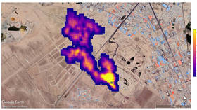
The Earth Surface Mineral Dust Source Investigation (EMIT) mission, which was set up on the International Space Station in July, identified methane hotspots using an imaging spectrometer.
The super-emitters include large oil and gas facilities, as well as landfills. NASA shared satellite images of such sites near Carlsbad, New Mexico, Tehran, and Hazar, Turkmenistan’s port on the Caspian Sea.
According to NASA, the survey and other similar research will help to better understand climate change. Methane, although making up just a fraction of human-caused greenhouse gas emissions, is estimated to be 80 times more effective in trapping heat in the atmosphere.
“We have been eager to see how EMIT’s mineral data will improve climate modeling,” Kate Calvin, NASA’s chief scientist and senior climate adviser, noted, adding that new methane-detecting tools will enhance ways of measuring and monitoring how greenhouse gas affects the planet.
In August, Space.com reported that other measurements from the EMIT team were aimed at creating “an image cube that shows the spectral signature of elements in Western Australia.” These include “exposed soils, vegetation, agricultural areas, rivers, and clouds.”
EMIT is also designed to measure the quantity of minerals, including dolomite, calcite, and gypsum, in the arid regions of the Earth.