China & Nepal put 2ft on Mt Everest as expeditions find world’s tallest mountain is higher than previously believed
Published 8 Dec, 2020 09:56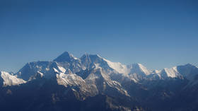
The Chinese and Nepalese governments have agreed on a new altitude for the world’s highest peak, Mount Everest, after sharing data from two parallel surveys which found the mighty mountain is actually 0.6 meters (two feet) taller.
While scientists and mapmakers have yet to analyze the findings, the new elevation for the highest point on Earth, 8848.64 meters (29,031 feet) above sea level, was reached by two separate teams employing cutting-edge technology and techniques.
Everest is now suspected to be 0.6 meters, or two feet, higher than the previous altitude recognized by the government of Nepal, according to a joint statement by the Survey Department of Nepal and Chinese authorities on Tuesday, following the first serious survey of Everest in 16 years.
Nepalese surveyors mounted the summit at 3am local time on May 22, 2019, ascending during the spring to avoid the ever-increasing crowds.
Also on rt.com Poo patrol: China demands Mt Everest tourists carry ALL their waste & shuts peak down for cleanup“We want to deliver the message that we can do something with our own [country’s] resources and technical manpower,” said Khim Lal Gautam, chief survey officer for the project.
Gautam and four team mates used GPS receivers and ground-penetrating radar to calculate the snowpack on top of the mountain as well as its height.
A further eight teams of surveyors waited patiently atop nearby peaks with a line-of-sight to Everest's summit in order to fix its elevation as captured at sunrise, using laser theodolites, precision instruments with telescopic sights used to establish horizontal and vertical angles.
Later, in the spring of 2020, a team of Chinese surveyors worked on the north face of the mountain, using China's network of BeiDou satellites, a rival system to GPS. The two groups then compared their findings before reaching a consensus, which has yet to be independently reviewed and therefore officially confirmed.
“In survey mapping, we can’t find the exact point or altitude,” Gautam cautioned. “We’re trying to find the MPV: most probable value.”
A 1954 survey placed the Everest summit at 29,028 feet above sea level, using theodolites, which became the internationally recognized standard.
Then in 1999, cartographer and explorer Bradford Washburn conducted the first survey using GPS technology, which found the mountain stood at 29,035 feet.
Geographers the world over have eagerly awaited such results following a devastating 7.8 magnitude earthquake in 2015, which many suspected would change the stature of the Himalayas mountain range.
Also on rt.com Deadly Nepal quake was long predictedThink your friends would be interested? Share this story!