New satellite survey reveals Africa’s deserts actually filled with BILLIONS of trees

A groundbreaking new study of high resolution satellite imagery using a deep-learning algorithm has found that, contrary to popular opinion, there are at least 1.8 billion trees in the Sahel and Sahara deserts.
A team of 24 scientists from across Europe, the US and Africa found that the so-called sub-humid zone is surprisingly filled with plant life, forcing a rethink of two of the world's major deserts and even public policy on deforestation.
“We were very surprised that there are quite so many trees growing in the Sahara desert,” lead author Martin Brandt, an assistant professor of geography at the University of Copenhagen, said.
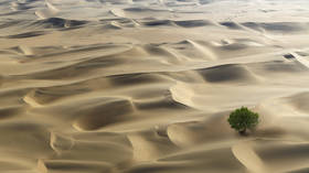
“Certainly there are vast areas without any trees, but there are still areas with a high tree density, and even between the sandy dunes, there are here and there some trees growing.”
The counting of individual trees over such vast areas of land would be a borderline insurmountable task were it not for computer deep-learning techniques.
Some 11,000 high-resolution satellite images, spanning 1.3 million square kilometers (around 500,000 square miles), were fed to a deep-learning algorithm that Brandt himself had to train by individually counting and labelling some 90,000 trees, in a process that took him an entire year.
“The level of detail is very high and the model needs to know how all kinds of different trees in different landscapes look,” he said. “I didn’t accept misclassifications and further added training when I saw wrongly classified trees.”
Also on rt.com World is literally a greener place than it was 20 years ago, according to NASA dataThe final count would have taken millions of people years of work, but was completed in a matter of hours, thanks to the powerful algorithm. It contradicts previous studies, which were based on estimates and extrapolations, and mapped close to zero-percent tree cover. In contrast, Brandt’s highly detailed, painstaking counting of individual trees revealed a density of 13.4 per hectare.
In even better news, the new study’s numbers are likely underestimates, as it excluded trees or shrubs with small canopies, counting only those with an average crown size of 12 square meters.
Experts who reviewed the research said that it will soon be possible to map the location and size of every tree around the world.
Think your friends would be interested? Share this story!


