Titan’s labyrinth: NASA captures complex terrain of Saturn’s moon (PHOTOS)
Published 30 Jul, 2016 13:20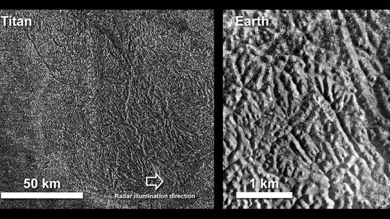
NASA’s Cassini spacecraft has captured a spectacular photo of Saturn’s largest moon, Titan, revealing its labyrinth-like terrain. The synthetic aperture radar (SAR) image was taken as Cassini passed over the southern latitudes of Titan on June 7.
The image covers an area of 87 by 75 miles (140 by 120 kilometers), and has a resolution of about 1,300 feet (400 meters). It also demonstrates a high standard example of "labyrinth terrain", according to NASA.
Labyrinth surfaces on Titan are thought to be higher areas that were cut apart by rivers of methane, eroded or dissolved as the region around them lowered.
This image reveals that a number of obvious valley systems have developed, which allow liquids from methane rainfall to drain towards the southeast.
On #Saturn's moon Titan, a labyrinth: https://t.co/1LHnRIfoAT and a ridge of jagged peaks: https://t.co/QOLRGmCDOMpic.twitter.com/4MT3xvLW4I
— CassiniSaturn (@CassiniSaturn) July 29, 2016
These systems run nearly parallel to each other, from upper left to lower right, suggesting that either the geological structure of the surface or the general slope across the area may be impacting their direction.
Beside the photo of Titan’s complex patterns, there is also a comparable aerial image of a region in southern Java, Indonesia, known as Gunung Kidul.
The region boasts a system of canyons called polygonal karst caused by limestone, which has been dissolved and eroded by water.
Again similarly to Titan, the canyons move from upper left to lower right, in this case as a result of faults or joints.
READ MORE:Rings of fire: Saturn’s moons split in awesome Cassini image (PHOTOS)
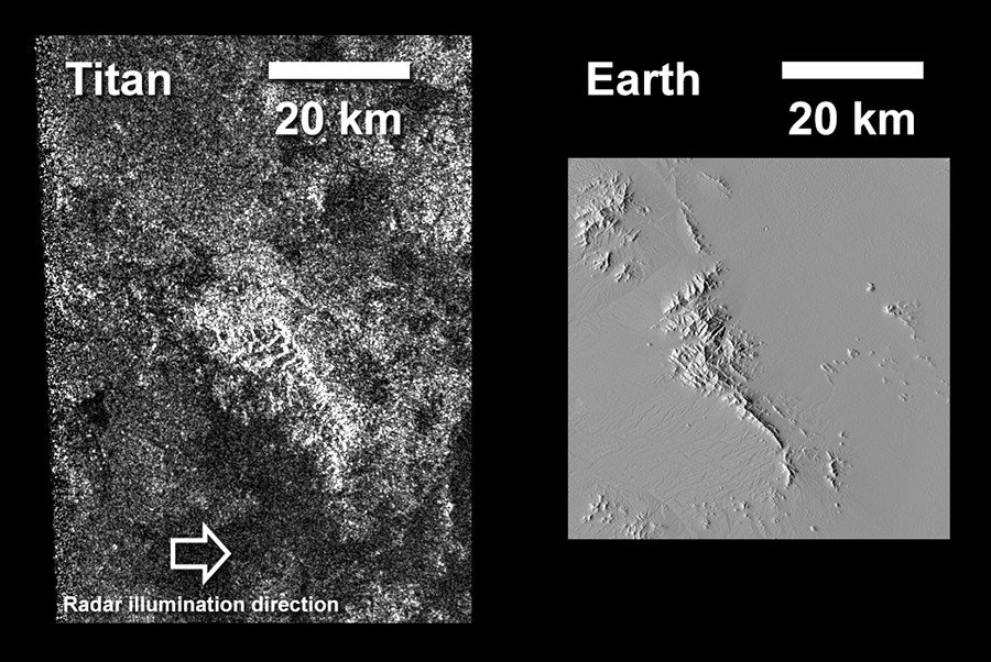
A second image shown above was captured at the same time and shows off a ridge of jagged peaks on Titan. It measures an area of about 40 by 60 miles (70 by 100 kilometers).
A bright feature, aligned from upper left to lower right, at the center of the image is believed to be a long ridge with jagged peaks, likely created by methane rainfall erosion.
The ridge has a considerably gentler slope on its left side than on its right.
The image is accompanied with a similar one of the Dragoon Mountains in Arizona just east of Tucson. The radar image shows it has a similar shape to that of the Titan ridge.
Titan has displayed many features that are strikingly similar to Earth including lakes, seas, rivers, dunes and mountains and scientists believe it is possible that it too has experienced movement of uplift and spreading, followed by erosion.
The Cassini Mission to Saturn launched in 2004 in the first in depth study of the planet and its system of rings and moons. The Huygens probe landed on Titan in January 2005.
READ MORE:Stunning NASA image reveals surface of Saturn's Titan moon