World’s top publisher ‘regrets’ erasing Israel from atlas meant for Middle East customers
Published 31 Dec, 2014 21:22 | Updated 31 Dec, 2014 21:24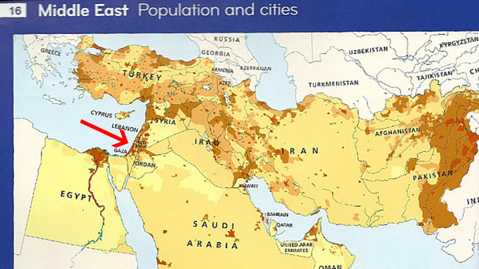
HarperCollins, one of the world’s largest publishing companies, has officially apologized for excluding Israel from its Collins Middle East Atlas because of “local preferences”. The publisher was accused of harming peace efforts in the region.
“HarperCollins regrets the omission of the name Israel from their Collins Middle East Atlas,” it said in a statement posted on Facebook.
The Atlas has now been removed from sale in all territories and “all remaining stock will be pulped. HarperCollins sincerely apologizes for this omission and for any offence caused,” the publishing house’s statement read.
Earlier, the Bishops’ Conference of England and Wales accused the publishing house of interfering with the peace process in the region by producing atlases that omit Israel from their maps.
“The publication of this atlas will confirm Israel’s belief that there exists a hostility towards their country from parts of the Arab world. It will not help to build up a spirit of trust leading to peaceful co-existence,” Bishop Declan Lang chairman of the Bishops’ Conference Department of International Affairs, told The Tablet.
In reply, the subsidiary of HarperCollins said to the same outlet that writing the name ‘Israel’ would have been “unacceptable” to their customers in the Gulf, so the change was to suit “local preferences.”
The map showed Jordan and Syria extending all the way to the Mediterranean Sea, with Gaza also marked, and was sold mainly to English-speaking schools in the Muslim region of the Gulf.
The Tablet also reported that other school atlases allegedly only reached the recipients when “Israel” was erased by hand.
Some experts said that allowing this to happen could de-legitimize the Israeli nation in the eyes of the students who would use the atlases.
“Maps can be a very powerful tool in terms of de-legitimizing ‘the other’ and can lead to confusion rather than clarity. We would be keen to see relevant bodies ensure that all atlases anywhere reflect the official UN position on nations, boundaries and all political features,” Dr. Jane Clements, director of the Council of Christians and Jews, stressed to The Tablet.
The omission also triggered anger among social network users.
Dear @HarperCollins, We've been here for almost 6K yrs. B4 textbooks or atlas' existed. Printed or not, #Israel will always be here.
— Manny B (@mb3992) December 31, 2014