India plans own version of GPS by 2016

India is steadily making impressive forays into space giving Western powers and China a run for their money.
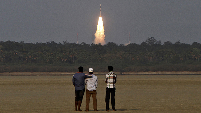
The latest example is the successful launch on April 4 of the second navigation satellite which will provide an indigenous alternative to the United States’ Global Positioning System (GPS) by 2016.
The satellite, launched by the Indian Space Research Organization (ISRO) from Sriharikota in the southern state of Andhra Pradesh earlier in April, is part of the seven navigation satellites project known as the Indian Regional Navigation Satellite System (IRNSS). ISRO had successfully put into orbit India’s first dedicated navigational satellite, the IRNSS-1A, was on July 1, 2013. The successful launch of the two satellites under the IRNSS program has catapulted India into a select group of nations with indigenously developed navigation systems.
Once the seven satellite IRNSS program becomes fully operational by 2016, it will not only positively impact the lives of common Indians but will also be a strategic game-changer with its immense defense, security and counter-terrorism applications.
Let’s try to decode this highly technical subject into everyday language.
IRNSS will provide two types of services: (i) Standard Positioning Service (SPS), which has civil usage and will be provided to all the users; and (ii) Restricted Service (RS), an encrypted service provided only to the authorized users, mainly to security and intelligence organizations.
Main features of IRNSS
• It will provide a position accuracy of better than 20 meters in
the primary service area.
• IRNSS consists of a space segment and a ground segment; the
space segment comprising seven satellites, with three satellites
in geostationary orbit and four satellites in inclined
geosynchronous orbit.
• IRNSS satellites would revolve round the earth at the height of
about 36,000 kilometers from the earth's surface.
• It will be useful in land, sea and air navigation, disaster
management, vehicle tracking and fleet management, integration
with mobile phones, provision of precise time, mapping, and
navigation aid for hikers and travelers, visual and voice
navigation for drivers.
• It can track people or vehicles and can be of immense use in
disaster situations like last year’s flashfloods in Uttarakhand.
• It will be a boon for the railways for tracking wagons.
• A highly accurate Rubidium atomic clock is part of the
navigation payload of the satellite.
Lesson learned
One of the biggest USPs of the IRNSS program is its range. It is designed to provide accurate position information service to users in India as well as the region extending up to 1,500 kilometers from its boundary, which is its primary service area.
According to Shri V. Narayanasami, Minister of State in the Prime Minister’s Office, its extended service area lies between primary service area and area enclosed by the rectangle from Latitude 30 degree South to 50 degree North, Longitude 30 degrees East to 130 degrees East.
The range of 1,500 kilometers means that India can extend its benefits to friendly neighbors and remain vigilant from cross-border hostile actions, be it in the form of changing patterns of troop deployment in the neighborhood or infiltration of terrorists.
Most importantly, India won’t have to look up to foreign countries in times of external threats as was the case during the Kargil War of 1999. When India noticed the Pakistani troops’ deep incursions in Kargil in the northern state of Jammu and Kashmir, India asked for American help and sought GPS data of the region to get the big picture of the threat. However, the Americans refused to cooperate. That was the time when Indo-American détente had not happened and Washington was closer to Islamabad than to New Delhi.
This was one of the most important lessons learnt by the Indians from the Kargil War as it underlined an urgent need for having an indigenous GPS-type navigation satellite network. This glaring security loophole would be effectively plugged once the IRNSS becomes fully operational by 2016 and that too at a highly economical cost of just about $ 300 million till then.
Besides, IRNSS will be an invaluable spy in the sky for India to safeguard its territory from terrorists.
Data generated by IRNSS will pinpoint exact locations of terrorists even before they are preparing to sneak into Indian territory.
The competition
Of course, much will have to depend on the Indian security personnel and how skillfully and efficiently they are able to collate and analyze the satellite data and take action against the terrorists.
The important thing is that India will not be at the whims and fancies of foreign countries in national security exigencies after the IRNSS program becomes operational in about two years. Currently only powers like the US and Russia have their navigational satellites fully operational. The European Union is working on an ambitious project called Galileo which won’t be fully operational before 2020.
China has its own regional navigation system called Beidou which it is in the process of expanding. Japan and France too are working to set up their own navigation satellites network.
India will be only the second developing country after China to have a network of navigation satellites which it will inevitably beef up in subsequent years, well in time before the ten-year lifespan of IRNSS comes to an end.
Last, but not the least, India can earn precious foreign exchange by exploiting this technology commercially and launching satellites of friendly countries. India has so far launched 31 satellites for 17 countries.
India’s strides in space technology can be an important source of making money as satellite launch is a lucrative industry worth billions of dollars.
Rajeev Sharma for RT
Rajeev Sharma is a New Delhi-based journalist and a strategic analyst who tweets @Kishkindha.
The statements, views and opinions expressed in this column are solely those of the author and do not necessarily represent those of RT.