Locate the Gulags: Google unveils more detailed North Korea maps
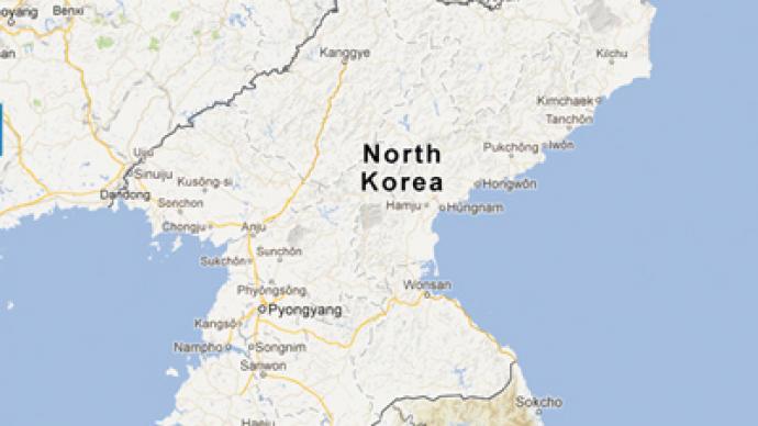
North Korea is now more than a blank square on Google Maps. The company has revised its maps application and added what it says is the most detailed plan of one of the most isolated countries in the world.
Until Tuesday the only spot labeled in North Korean territory was its capital Pyongyang. Now the update shows not only roads, railway stations, hotels and restaurants, but also the country’s several city-sized “gulags”. When zoomed in the grey-colored camps can be easily identified. In the country’s northeast, for instance, Google has labeled what it calls the “Hwasong Gulag.” It’s cut through by a street called Gulag 16 Road, after the Gulag 16 Checkpoint that is also labeled on the new map. The first user reviews are mostly ironic. One of the “tips” suggests avoiding the checkpoint if “cavity searches” is not “your cup of tea” and proceeding straight to the gulag. According to a Google post, the map is a work of “a community of citizen cartographers” that voluntarily have been working on it through an interface known as Google Map Maker since 2009. In the case of North Korea, where access to the full-blown internet is restricted, a number of volunteers were working from outside of the country. They used information that was already public, bringing together details from analog and satellite maps. The data was fact-checked in a similar process to that used by Wikipedia.“As a result, the world can access maps of North Korea that offer much more information and detail than before,” Jayanth Mysore, a senior product manager at Google Map Maker said in the statement posted Monday. However, the new map is said to have less information than other maps created by private efforts with the help of a different Google product, the satellite image program Google Earth. One of the maps was created by Curtis Melvin, who runs the North Korea Economy Watch blog. He also spent years spotting landmarks in North Korea. In addition to a lack of information, the map fails to provide routes from one spot to another. “We know this map is not perfect,” Google said in a statement, calling for people from around the world to continue helping to improve the maps’ quality. As for who is to benefit from the new service the Google Map creators expect that it is most likely to be users from South Korea. “While many people around the globe are fascinated with North Korea, these maps are especially important for the citizens of South Korea who have ancestral connections or still have family living there,” Mysore wrote. With the two countries still technically at war, decent maps of the North are reportedly almost impossible to obtain in South Korea. The release of the maps comes just weeks after Google Chairman, Eric Schmidt, visited Pyongyang. But his visit was unrelated to the map roll-out, a Google spokesman said.