Beam me down: NASA’s GEDI laser to 3D-map Earth’s forests
The US space agency will attempt to map the earth’s forests in 3D, turning its “Lidar” laser device earthwards to precisely measure the depth and shape of terrain from above. The project, called GEDI, will be completed in 2018.
NASA hopes that using the laser instrument to construct precise
forest measurements from the canopies down will allow them to
draw data and conclusions about their roles in the carbon cycle.
"One of the most poorly quantified components of the carbon
cycle is the net balance between forest disturbance and
regrowth," Ralph Dubayah, EDI principal investigator at the
University of Maryland, said in a NASA statement.
“GEDI will help scientists fill in this missing piece by
revealing the vertical structure of the forest, which is
information we really can't get with sufficient accuracy any
other way,” he added.
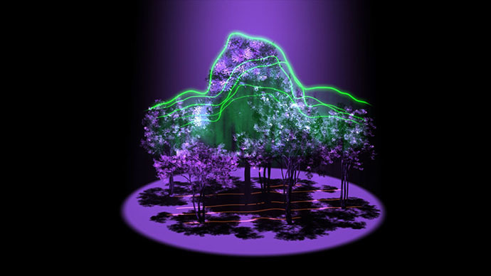
GEDI is an acronym for Global Ecosystem Dynamics Investigation.
The device itself will use a specialized laser “Lidar” technology
system technology and be produced at Goddard Space Flight Center
in Greenbelt, Maryland.
“Lidar has the unique ability to peer into the tree canopy to
precisely measure the height and internal structure of the forest
at the fine scale required to estimate their carbon
content,” said Bryan Blair, deputy principal investigator
for GEDI.
Lidars – a portmanteau of ‘light’ and ‘radar’ – have been used to
map things like craters, geological formations, and even monitor
ice melting. However, they have never previously been used to
examine forest density.
Three laser beams will be deployed. Using a complex system of
optics, they will be divided into 14 tracks on the ground, spaced
approximately 500 meters apart.
University of Maryland vice president and chief research officer
Patrick O'Shea explained how the technology would aid with carbon
measurements.
“In particular, the GEDI data will provide us with
global-scale insights into how much carbon is being stored in the
forest biomass,” he said. “This information will be
particularly powerful when combined with the historical record of
changes captured by the US’s longstanding program of
Earth-orbiting satellites.
“GEDI lidar will have a tremendous impact on our ability to
monitor forest degradation, adding to the critical data needed to
mitigate the effects of climate change,” O’Shea said.